|
Computer
Stereo
Imagery
|
all images copyrighted to Richard Grotjahn
Computer-drawn images of weather data
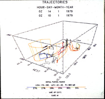
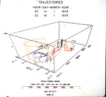
Three dimensional trajectories near east coast of Asia (viewed from
the southwest) Colors denote equivalent potential temperature. Time passage
of about 2 days. Illustrates how air forming the cloud mass in the warm air
actually has its origin in middle and higher latitudes.
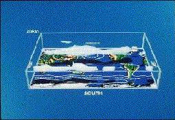
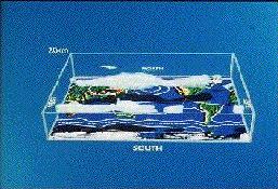
Global jet streams averaged over January 1979 (FGGE data). White
volumes enclose wind speeds greater than 35 m/s. Shadows are cast from a
light source above the north pole (so they are a bit south of where the object
lies above). Sea level pressure contours. See my
book for more details, since a
non-stereo version of this image (plate 1) is discussed there.
Return to my Stereo homepage.
Note: "back" may be quicker on some internet viewers
Return to my homepage.
Return to UCD Atmospheric Science
home page.